Running Towards Data
/
Being a data geek and a runner, it's probably not that surprising that I wear a watch for each run. By downloading the data, I have information about my speed, my distance, my heart rate, and even GPS information about where I ran. I noticed a really cool feature on my GarminConnect account (the website I use to log all of my runs) using that GPS data. Not only could I see a map showing where I ran, but one that compiled all of the data into a heat map showing where other users had run as well.
For users, this feature is really cool if you think about it creatively. If you're looking for a new place to run in your area, just zoom in to a nearby area to see where other runners are going. Also cool, you can zoom out further to get a quick glimpse into the best running cities in the USA. And even better, when you're in a new city, you can use websites like these to figure out where the most popular running paths are. This came in incredibly handy when I visited Europe last fall. It turns out that not many people run in Sarajevo, but luckily my hotel was right next to the most popular street in the city.
This got me thinking though....if I can look at this data to find out where people in my area are using their walking, running, and biking paths, couldn't local governments also use this data to help determine the popularity of those paths that they maintain? Data like this could help set priorities for capital improvements and additional amenities like water fountains, signage, and bike racks. It could also help local govnements determine where they need to focus on installing new paths, especially ones that may connect two well-used paths.
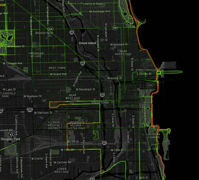
Strava runners in Chicago
Turns out my hunch wasn't that far off. Last fall, the state of Oregon actually paid Strava, a well-known app used by cyclists, $20,000 for a one-year license of a dataset that includes the activities of about 17,700 riders logging 5 million miles on their bikes. Interested in seeing an overview of data in your area without the pricetag? Strava has now posted information online for advocacy groups and the public to view at http://labs.strava.com/heatmap/. On this site, you can view biking, running, or both. Strava is generally more popular with cyclists than runners and walkers, so you may want to also look at Garmin data, and other popular websites like MapMyRun.
Of course, it's important to recognize that the data that these maps show is not representative of the general public. In fact, many of these data points come from more serious runners and cyclists than the majority of your users. However, knowing how hard it can be to get any sort of data on these types of user groups in your parks, it may be an important first step. What do you think about this opportunity for local governments? Has your agency ever used data like this before? And if you're a user of apps like Strava and Garmin, what do you think about your data being sold?